 |
GEOGRAPHICAL SETTING OF AFIZERE NATION
The geological setting of Afizere nation can be traced back from the pre-colonial era where the people only lived in clan settlements.This started from time immemorial. Later, early 19th century featured the colonial administration where excise of
Regions, Provinces and Divisions took place. This era saw Afizere nation clearly bounded by the Anaguta, Birom and Rukuba tribes as immediate neigbours. Although the excercises were done in various regimes which perherps may not all feature here, the most significant and relevant are these displayed on this website
The map below is an extract of National Archive of the Federal Republic of Nigeria titled ASSESMENT REPORT ON NARABUNU TRIBE OF BUKURU DISTRICT, NARAGUTA DIVISION BY MR. S. E. M. STOBART. ASST. RESIDENT.

CLICK IMAGE FOR FULL VIEWdownload Certified True Copy of this document
From the map, Mr Stobart who was the Asssistant District Officer of Bukuru District of the Division noted that a tribe named Narabunu
live in the Nothern and North Westhern side of the district share boundary with Lumoro tribe to the north. Also in boundary with Bauchi Emirate on the eastern side, south by Jarawa (Afizere as indicated by the arrow on the map) and Anaguta tribes
then south west by the Ba and Rukuba tribes.
From his writting: 1. The Narabunu tribe live in the Northern and North Western
portion of Bukuru District, and farm below the plains on
the Plateau bordering on the Zaria Province. The total
area of the district is 14 square miles.
2. The tribe is bounded on the North by Sangawa (Lumoro),
on the East by the Bauchi Emirate, on the South by the
Jarawa and Anaguta tribes and on the West and South by
the Ba and Rukuba tribes.
3. The North Western boundary of the tribe forms part of
the boundary between Zaria and Central Province.
A copy of this report along side its map was farwarded to the secretary of the Northern Provinces F. Beckles Gall as
Provincial Administration Report by the Resident of the central province in June 30th, 1914. And today, it has become a reliable
historical document of the nation savely kept in the Archives as certified true copy.
REF: 493P/1914(ASSESMENT REPORT).
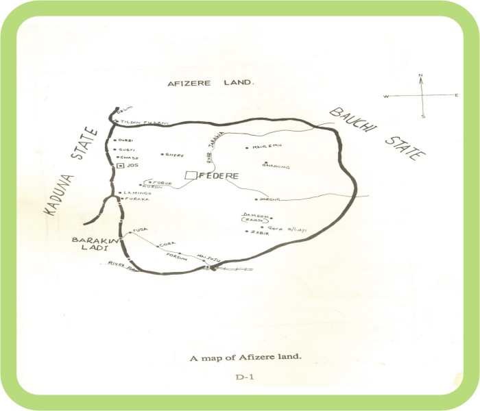
Afizere geological bounded nation was futher deduced from the one above as shown below. It is titled
MAP OF AFIZERE LAND
CLICK IMAGE FOR FULL VIEWdownload Certified True Copy of this document
The thick black line indicates clearly the bouded regions of entire Afizere Nation. This excise came more recently than the one first shown above - cardinal point beside showing Bauchi Division
(meaning the excise took place during the provinces, Divisions, Districts and Villages Era). Whereas the latter show Kaduna and Bauchi states respectively at the sides with the map in the middle - implying also that
it came during the post colonial era excised by the Government of the Federal Republic of Nigeria itself. The cardinal point is a very good guide in reading through and clearly
understanding the nitty-gritty therein.
Fusa, Gora and Maijuju is bounded by Barikin Ladi Local Government Area to the south and south west.
Then some part of Fursum directly inside Barikin Ladi - meaning some Afizere people constitute
the indigenship of that local government area. Dorong, Zabir, Zambi and parts of Gora also bounded by
Barikin Ladi at the Eastern and South Eastern side. Maigemu, Gwodong and some parts of Jarawan Kogi are
bounded by Bauchi state to the North and North Eastern side. Gwash, Lamingo, Furaka, and Jos
(Jos Jarawa, Kabong, Gyese(Tudun Wada), Dong Districts) to the North and North Western side.
Aside from official colonial documental revelations, oral revelations from both Afizere, Anaguta and Rukuba tribes
have it that they have been living close to each other even though there have been clashes (of the olden days) among them. Harmonial
relationship existed between Afizere and Anaguta, being their most closest and friendly neighbour
. The do not only share boundaries but also most aspects of their culture. According to C. G. Ames (1932), the Anaguta tribe have assimilated
much of Afizere custom as a result of long time alliance. They fought side by side against the Fulani jihadists and against
the Rukuba tribe.
However, as the environment increase in population and economic activities improves among other things
by the year so many people from different places including some neighbouring tribes became attracted
. As lovers of peole (see Afizere Culture), Afizere embraced all. At some point in time, friction and challenges arose especially
between Afizere and their Berom brothers over the land matters in some parts of Jos North and Jos South Local Governtment Areas
inspite of high number of inter-marriages amongs them so much that they consider themselves as one and also share some common cultural values together among other things.
This consequently resulted in different litigations instituted to seek redress ranging mainly from land ownership to chieftaincy tussle.
Till this day, Afizere, Anaguta, Birom and Rukuba still share common boundaries.
|